Unpicking a tapestry
Today off with the drone to North Uist to a site where we knew there was some form of circular enclosure. The light was flat and so the imagery from the drone did not throw the various dykes into the contrast one might have hoped for. It does however illustrate how the land here has been used, reused and reused again.
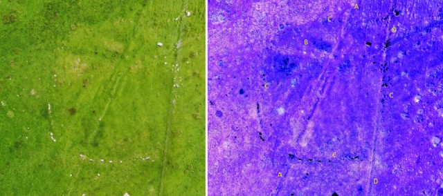
Playing around on a piece of photo editing freeware prodcued the image on the right from the image created from several drone images on the left. I think the modified image does make it a bit easier to understand the chronology.
D is a modern barbed wire fence probably put up in the last fifty years whilst A is a turf dyke that fits into the original orofitng landscape of c1815.
C is not so clear but on the ground is more apparent and is another turf dyke running at rright angles to the other two and from the crossing points must predate both A and D but is later than C.
C is the interesting one, a sub-rectangular enclosure almost 30m in diameter created by a dyke and several large stones. Other than being the oldest of the structures here, how old is impossible to tell without getting a trowel out.
The name of the area, Cleit, is an Old Norse one and the fact it is both a simplex name and topographical (to blind you with science) indicates it was one of the first Norse settlements in this area. Either way it is an interesting and pretty area.
Talk yesterday of no fish this week was premature with neighbours D&I asking if we wanted a couple of pollack that they had just caught. Rude not to and very fresh and tasty they were too.
r
178
views
- 1
- 0
Comments
Sign in or get an account to comment.


