An Cliseam
At the first hint of lightening skies I was up and out of the battered tent, packing it away amazed there was no damage. I climbed back up to the bealach into the cloud and persistent wind. After a while the slope of rubble leaned back to form a narrow rocky arête a bit like the Forcan ridge. I was glad of the cloud around me hiding what was no doubt a spectacularly exposed spot. The summit of Garbh Bheinn was typical of the Cuillin, a handful of mossy stones perched on the edge of a cliff. Corbett#211...
I descended the north ridge, now grateful for some evidence of other walkers, crampon scratches on the rocks, the odd footprint in the basalt mud.
At the next bealach where my planned route would head up Marsco (shrouded in clouds as ever), I spied an ‘easy’ traverse across its grassy northern flank as a bypass. Even better, it would take me to the route used by Charles Edward Stuart in 1746 whilst alluding those pesky Redcoats who were guarding the coast road.
From the boggy pass I picked up a well trodden footpath and descended north beside the river into the wide strath below. The closer I came to Sligachan the wider came the path and soon enough I was amongst the hoardes of tourists waving phones about at the old bridge. This place has changed a lot since my first visit in 1991, there were so many rental cars, camper vans and tour buses slowing at the junction to weave across the median gazing at the cloudy hills.
Eventually my next transport arrived- the 1st bus to Uig on a Sunday is at 12:50.
Now that Skye was compleat, next up was An Cliseam, my remaining Corbett in the Western Isles.
Thankfully the bus arrived at Uig in time for the ferry, though the new ferry terminal operations unnecessarily required foot passengers to be put in a minibus for the 200m drive to the boat.
Across the Minch and onto Harris by 4pm, frustrated to see the low cloud was here too and no summits visible. I marched purposefully out of the village onto the Stornoway road then stuck my thumb out at every passing car. Within a mile I had a lift from a friendly local who had been kayaking down the west coast. He zoomed me up to the high point of the road and I jumped onto the moor.
The route up the hill is muddy slop interspersed with rocks. That’s about all I have to say about An Cliseam. Oh and it’s the jewel in the North Harris mountain landscape. But only the map told me that.
Quickly back to the road as it was now 6:30, I crossed over straight onto the moor and splodged east to the green ribbon of the Hebridean Way in the distance. What a relief it was to step off the wet slop on to a constructed path!
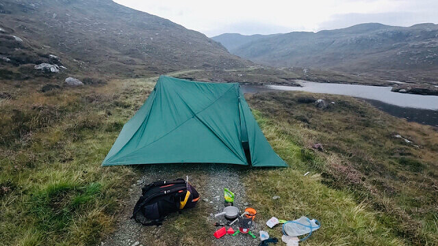
South now, over the pass and down the zig-zag to the shore of Loch Lacasadail, the wind just a light breeze to keep the midges at bay. I camped astride the flat path, safe in the knowledge that none would pass before my early departure to the ferry tomorrow.
Corbett #212…......10 to go…
Comments
Sign in or get an account to comment.


