
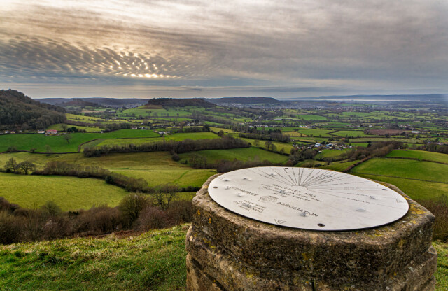
View from the Topograph of the Severn Vale
I felt like blowing some of our holiday cobwebs away, so I suggested to Woodpeckers that we drive up to Coaley Peak on the edge of the Cotswold escarpment. It is a classic viewpoint located about 4 miles south-west of Stroud overlooking the village of Coaley, with views over the Severn Vale and the Forest of Dean. It is next to a Woodland Trust beech wood and the National Trust's Frocester Hill site and the Cotswold Way long-distance footpath passes through the site beside the excavated Neolithic burial site called Nympsfield Long Barrow
Some decades ago the Automobile Association erected this topograph, on National Trust land on the side of Frocester Hill, the top of which can be seen in the picture. You can probably read some of it if you go large! The lines point to various landmarks of the landscape, on both sides of the River Severn whose estuary can be seen in the far distance. Beyond the river is the Forest of Dean and the Welsh foothills.
I'd hoped that the day's rather lovely earlier sunshine would prevail but by the time we left home the cloud cover was rolling in from the west. As we were returning to the car the darkness was beginning to prevail so the light on the landscape is not very flattering. But we both agreed that it is always good to get out of the Five Valleys of Stroud and to let our eyes wander to the far horizon and take in the bigger picture.
The long hill in the middle distance is called Cam Long Down close to the village of Alley and nearby town of Dursley. The hills on the left which form the escarpment are formed by the Carboniferous limestone which underlies much of the Cotswold hills. The valley is a complex area geologically with mostly clay underlying the rolling farmland, with occasional outliers of limestone, such as Cam Long Down.
Comments
Sign in or get an account to comment.


