Success
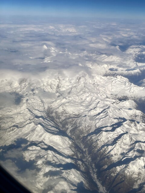
I finally managed to geolocate this photo snapped today flying from Florence to London.
It is the Valley of the Lys in Aosta. The Frozen Lake - the Gabietsee at middle right ( in the centre of the thumbnail) is at (45.8474578, 7.8469983) in the Monte Rosa massif. To right of valley end in cloud is the Dufourspitze which at 4634 metres peak is the highest Swiss alp. That’s possibly Matterhorn top leftish poking through clouds.
The Monte Rosa has ten peaks higher than 4,000 m. The Dufourspitze was named after the cofounder of the International Committee of the Red Cross, General Guillaume-Henri Dufour, in 1863.
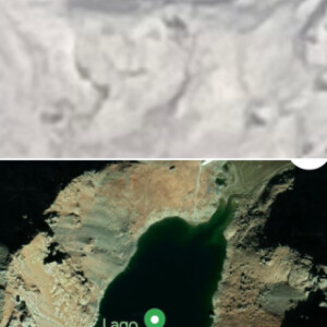
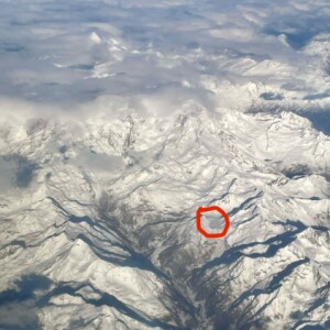
I finally made the identification by coming across the Gabietsee on Google Maps using the vague sense of location I had when we were 25,000ft. up. See extra comparing lake in photo with Google Maps satellite image. And duplicate photo with lake marked.
I think I shall make it my ambition visit the lake (addressed at 11020 Gressoney-La-Trinité, Aosta Valley, Italy) either by cable car or walking. It’s at 2,373m altitude. The Lys/Gressoney valley sounds delightful and is flanked on either side by the Pennine Alps. It’s a six hour and forty two minute drive from the house in the Casentino although last section is a private road. There is even a bar by the lake!
We were on the road for over 12 hours what with early morning dentistry in Florence and a delayed connection at London City.
Comments
Sign in or get an account to comment.


