O Marks the Spot
Today's theme is Triangulation.
These geodetic survey markers are found near the top of all the mountains around here and at various points along the coast. This one was on top of Flying Mountain, which my wife and I hiked over this morning. The arrow is pointing towards the spot I took yesterday's photo.
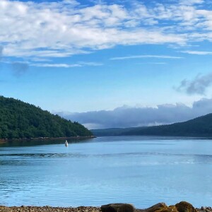
In the extra, Acadia Mountain is jutting out into the center of the image behind the sailboats. If you go back to yesterday's photo, you can just about make out the beach I was standing on today. In that image, the sailboats are hidden behind the shoulder of St. Sauveur Mountain, but you can just make out a marking buoy at the mouth of the cove.
In today's extra we are looking north up Somes Sound. St. Sauveur is actually just behind Valley Peak on the left, and Norumbega is across the water to the right.
To my astonishment I seem to have neglected to ever post any photos from Norumbega Mountain, even though I hiked it just the other day. I have even deleted all the photos I took on that hike. Hmmm...something to put on the to-do list.
Edit: After some further searching, I found it. Of course I've posted from Norumbega before!


Comments
Sign in or get an account to comment.


