Roll On Columbia
Roll on, Columbia, roll on.
Roll on, Columbia, roll on.
Your power is turning our darkness to dawn,
Roll on, Columbia, roll on.
Other great rivers add power to you,
Yakima, Snake and the Klickitat, too,
Sandy Willamette and Hood River, too;
Roll on, Columbia, roll on.
- Woody Guthrie
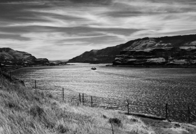
This photo is taken on the Washington side of the Columbia River, between the Klickitat River and Hood River, a couple of miles west of Lyle, WA. Across the river on the Oregon side one can see the Rowena Gap (aka the Ortley Anticline).
For geology aficionados read on for more about the development of this unique region...
"The Rowena Gap is a 5.5 miles long by one-mile wide water gap, and resulted when the Columbia River carved a narrow channel through the Ortley Anticline, a folded feature of the Columbia River Basalts. These massive fissure lava flows covered quite a bit of Idaho, Washington State, and Oregon; and are between 17 and 5.5 million years old.
The basalt face on the Washington side of the gap is the western edge of the Ortley Anticline known as the Columbia Hills. The Columbia Hills is an expansive section of hills rising over 2,000 feet above the Columbia River, extending from the Klickitat River on the west and continues east overlooking such areas as: Maryhill Museum, Stonehenge Memorial, the John Day Dam, and the Haystack Butte area where Lewis and Clark camped in 1806 when exploring the Pacific Northwest.
The Columbia Hills is the western edge of a much larger region called the Yakima Fold Belt. This belt is a section of lava flows of Columbia River Basalt extending along the northern banks of the Columbia River east of the Cascade Range. The Yakima Fold Belt consists of a series of generally east-west-trending anticlinal ridges (high points) and synclinal valleys (low points) that were produced under north-south regional compression. These folds extend from the southern Columbia Plateau into and through the Cascade Range. Folding was initiated during middle to late Miocene time (17 to 5.5 million years ago) and has continued to this day."
From website: The Columbia River: A Photographic Journey (http://columbiariverimages.com/index.html).
Comments
Sign in or get an account to comment.


