
West Gate
In keeping with my mini-project to photograph old place names around town, here is a plaque that tells the history of Malmesbury's West Gate in the town's Medieval defensive wall.
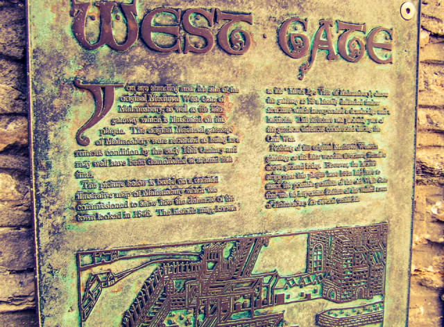
In case you're interested it reads:
You are standing on the site of the original West Gate of Malmesbury, as well as the later gateway which is illustrated on this plaque. The original Medieval gateways of Malmesbury were recorded as being in a ruinous condition by the early 16th Century and may have been demolished at around that time.
The picture below is based on a detailed illustrative map of Malmesbury which was commissioned to show how the defences of the town looked in 1646. The historic map, known as the 'Birds Eye View of Malmesbury', shows the gateway to be a heavily defended timber structure which incorporated a drawbridge and a barbican. This structure was probably part of the garrison defences constructed during the Civil War.
Nothing of the original Medieval Western gateway, or the later wooden structure remains above ground today. However, the bronze strips near this plaque have been laid here to mark the possible position of the old West Gate that was an important feature of the walled town of Malmesbury for several centuries.
140
views
- 0
- 0
- Eastman KODAK Z650 ZOOM DIGITAL CAMERA
- 1/50
- f/2.8
- 6mm
- 80
Comments
Sign in or get an account to comment.


